23
\$\begingroup\$

I have been gamemastering tabletop RPGs for years now, but I'm still wondering what is the best way to deal with this.

Specifically: how to graphically describe to your players their surroundings when they crawl in a dungeon, explore a spaceship or sneak into the local inn by night. The goal being for them to discover the architecture of the place as they progress inside, without any initial idea of its size, main rooms or exits.

What technique are most effective, to this end?

Ideally I'd like a solution that doesn't require electronic devices nor too much preparation work, and requires minimal drawing.


I have used the following methods in the past:

  • Verbal descriptions of the places, no map. The players can still try to draw plans themselves, but I do not tell them when they get it wrong.

  • Provide them with a full map of the place, without any characters nor objects at first. (For multi-level areas, possibly only revealing new levels as they enter them.) I allow myself to later reveal that some paths are obstructed, or that some hidden passages exist.

  • Draw the map progressively as the players explore. (Sadly, I am a bad drawer.)

  • Use map tiles. (Usually from board games like Twilight Creations Inc.'s Zombies!!!.)

  • I once used pages of 3x5 white label stickers, drawing the map on them beforehand. During the game I progressively added the stickers to a large white sheet as the players discovered the rooms of the abandoned facility.

This question is related, but not similar to, Could a "Fog of war" prop break a game in any way?

\$\endgroup\$
4
  • 2
    \$\begingroup\$ This question could be fine. All questions that generate multiple answers are not a "list question." A list question just asks for a big ol list of things with no criteria for what would be best or most helpful. A good question asks for the best solution someone's used for a given purpose, and there will be multiple answers from multiple perspectives but some would clearly help more than others. I find this close to reopenable at this point - any more you could add about desirable or undesirable attributes of a solution would help. \$\endgroup\$
    – mxyzplk
    Commented Dec 3, 2014 at 0:31
  • \$\begingroup\$ Could you describe what you found good and what you found lacking in the solutions you've used before, to give answerers more understanding of what features a good solution should and should not have? \$\endgroup\$ Commented Dec 3, 2014 at 18:24
  • 2
    \$\begingroup\$ @mxyzplk Right now this is drawing "I do it this way" poll-style responses that lack any analysis of pros, cons, or fitness for the asker's purposes. I think that's the problem that the original close votes were anticipating, and that the question needs more criteria to draw something other than just a list of anecdotes. The dearth of voting seems to point in that direction too. \$\endgroup\$ Commented Dec 3, 2014 at 20:14
  • \$\begingroup\$ It's gotten one more answer since reopening and it seems like a good one. I'm not sure why everyone's getting wrapped around the axle of this question as it's just like any other "how do I" GM technique question. Add a meta Q if you really think it merits more unpacking. \$\endgroup\$
    – mxyzplk
    Commented Dec 3, 2014 at 20:21

8 Answers 8

8
\$\begingroup\$

I print off custom maps from map creators, then lay an acrylic sheet over top. The hard surface is easier to place minis on and you can use dry-erase markers to augment the map with traps, AoE effects, etc.

To add Fog of War to this setup, I use butcher paper in between the map and the acrylic then slid it out as the players progress. I have also used overlay map pieces (from the map creators) to hide portions of the maps (a roof for the hut, cave rock texture, etc.). From the player's point of view, they see a large map with a full-colour map texture but no paths or rooms or interiors. These pockets get 'revealed' as they get in range. It has worked well for my games.

\$\endgroup\$
2
  • \$\begingroup\$ Awesome ideas ! I know it's out of the scope of the question, but do you have reference websites where you get those maps ? \$\endgroup\$ Commented Dec 3, 2014 at 21:21
  • 1
    \$\begingroup\$ I've settled on pyromancers.com/dungeon-painter-online recently \$\endgroup\$
    – schroeder
    Commented Dec 3, 2014 at 21:23
3
\$\begingroup\$

I've played the majority of my tabletop games online over the years. Therefore it's easy to use a site like Roll20, which offers a built-in Fog of War option. I personally don't really see an issue with using something like this in a live session, but typically I just don't draw maps at a face-to-face session unless the players have rolled initiative or it's suddenly become important for the players to know the spatial dimensions of their surroundings.

Being good at drawing is a non-issue, really. If you have Parkinson's or something else that would make it difficult just for you to draw a straight line, then I would advise that you use a computer screen with a tile-based map builder, such as MapTools or Roll20. Otherwise keeping it as minimalist as possible ensures that the players take heed of your verbal descriptions more carefully, not to mention it's just better for the imagination if there isn't a representative image of what you're describing in front of you. Maps are best used to solve practical problems such as "I need to make sure I'm in this position so I can execute these attacks," or "I need to know how long this corridor is so I can know how long it takes me to run to the end." I never use maps as the aesthetic presentation.

\$\endgroup\$
3
  • \$\begingroup\$ I often prefer relying solely on descriptions too, but my question was specifically about those situations where giving a map to your players would really help them. E.g. if they have to organize the defence of a large place like a castle or a crashed spaceship. \$\endgroup\$ Commented Dec 3, 2014 at 21:29
  • \$\begingroup\$ Then I would just use MapTools or Roll20. Hell, if you wanted to get fancy, you could use a projector or TV and hook it up to your computer's display output. Basically you'd have your own monitor/screen that the players can't see where you're actually revealing/hiding the fog of war areas, then on the projector or TV you'd have another browser window open connected to the same session as a player instead of a GM. That way, they'll see the fog of war as solid instead of transparent like GMs normally do. You might also be able to set the opacity of FOW as a GM which would make it easier. \$\endgroup\$ Commented Dec 3, 2014 at 22:23
  • \$\begingroup\$ Also, this sounds complicated, but it's worth it if you don't have the cash to shell out for expensive miniatures and tile pieces or terrain, or the artistic skill required to draw a nice-looking map, but still want to have a nice-looking map. Plus, once you've set it up once, it's not much effort to set it up again. The projector/TV option also allows you to have a digital map without necessitating that everyone else bring a computer. Even fancier, if you could project onto a whiteboard, the players could make their own markings directly on the image. \$\endgroup\$ Commented Dec 3, 2014 at 22:25
2
\$\begingroup\$

The way I've done this in the past has been drawing the map progressively, you don't need to be a good drawer. You just draw in lines for walls, and doors etc. You can get a cheap whiteboard from any number of shops along with some dry-wipe markers (or just laminate some sheets of paper). Use that for the game board with a grid across it for scale/size and it's easy to draw in walls along the grid lines.

i.e. "you enter a 30' square room with two doors in the far wall", draw in the shape of the room and location of doors, then continue the description of the room for flavour.

I've also heard of this being done using scenery (wall) props. As players explore you just place more walls.

If playing online then tools like MapTools provide line of sight and vision calculation facilities that automatically handle fog of war for you.

One option I've considered but never used is laying out the map and then covering it in sheets of A4 paper. I can then slide/remove those sheets of A4 paper to reveal more map as the players explore.

One thing I don't recommend is just revealing the map ahead of time. That can spoil a lot of the fun and feeling of exploration, of not knowing what is around the next corner.

\$\endgroup\$
2
  • \$\begingroup\$ Going off the A4 paper idea, I've heard of a prepared map being covered with a large towel and slowly being reveled as they progress further in. Use the vision radius of the characters to determine how much to show. The large towel hides the size of the map. \$\endgroup\$
    – Korack
    Commented Dec 2, 2014 at 17:40
  • \$\begingroup\$ The whiteboard idea is good, I used one several times. Thanks for your suggestions ! \$\endgroup\$ Commented Dec 3, 2014 at 21:25
2
\$\begingroup\$

As a master i faced this problem since the beginning: i always like to include some sort of exploration in my adventure, and wide fighting areas, resulting in big maps.

The best and practical way i use to deal with it is to draw the map while the characters see the actual part of it, but dividing the map in "drawing zones".

When the characters step in another zone i erase the previous zone and draw the start of the new one, but only the part of the zone they can actually see. To figure this out think at the mechanics of different stages\maps and fog of war in games like Baldur's Gate.

This has several main effects:

  • It is a kind of fog of war. Stepping in another zone doesn't precludes of events happening in other zones, and what the characters (and the players) can actually see it's always at best just a section of the map.

  • You can play with miniatures in fairly big areas, allowing more combat and tactical options.

  • My players started drawing their own maps, so they can have a general vision of where they are. Imagine an underground complex which you draw in, let's say, 8 interconnected drawing zones. At some point the characters will figure that going by memory is not an option, and maybe they'll start freaking out for the fear of getting lost, or not having an escape route for a bad situation.

As for the drawing surface, two solutions provided the best results in the years (forgive me for strange english terms, i'm not a native speaker):

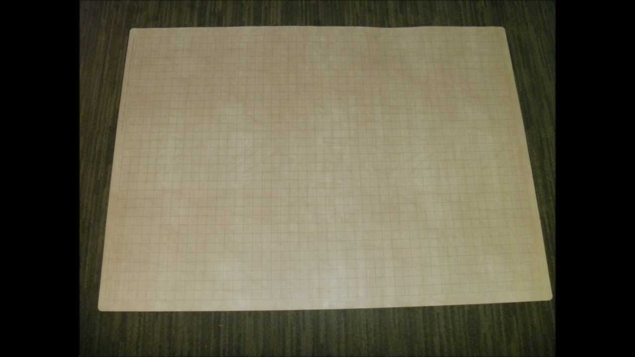
1 - A foldable vinyl or plastic sheet, gridded and drawable with eraseable markers. Mine is 80x60 cm. Should be something like this:

enter image description here

The real plus is to have it gridded and usable on both sides, so you can always have 2 zones drawn.

  • Draw the first zone on one side of the sheet and the second on the other side.

  • If the characters step in the previous drawing zone, you just have to flip the sheet and not to draw it again.

  • When they step on the third zone, flip the sheet and erase the first zone.

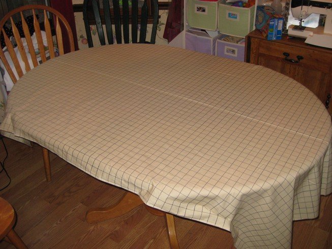
2 - A foil of bright white vinyl from a fabric store which can be drawed and erased with water markers. We found a local store which sold it like plain fabric is sold, in a big roll, cut per meter. Then draw a squared grid on it with permanent markers (or find a gridded one). So you can have a permanent grid while drawing and erasing with water markers. The result should be something like this:

enter image description here

Worked well in big events - boss fights, sieges, ecc - and with situation where the entire map is known to the characters. But the actual space on the table is always a bit messy for player objects, beers, sheets, beers, dices and beers. So we decided for the first solution while playing normally.

\$\endgroup\$
0
\$\begingroup\$

Most big screen TVs (small screen ones, too, I guess) can act as monitors nowadays, especially with HDMI. I've run games with ScreenMonkey before with that kind of setup. I had to move the player's minis, tho. They sat around on the couches and used a laser pointer to show me their moves. I'd probably do it with Roll20 or MapTool, nowadays.
So, if you have a computer with HDMI out or some other connection option and a largish screen TV, you can do this with little expense.

\$\endgroup\$
0
\$\begingroup\$

... I'm still wondering what is the best way to deal with this.

The reason you are still wondering is because there isn't a best way. The best way depends on the needs of the particular game system and the objectives of the players.

For example, let's say I have an adventure set in the Sydney Town Hall. What kind of geographic information do the players need?

First they need to get there.

  • If that involves hailing a cab and saying "Sydney Town Hall, please" then they need no geographic information.
  • If they are catching a train or a bus then I might give them a network map; unless they are total idiots (a possibility a GM should always be cognisant of :-)) it will take then about 30 seconds to work out that getting off at the stop labelled "Town Hall" might be a good start. The network map is a particularly important resource to consider because it focuses on connections between areas not distances between them: which do they need?
  • If they are traveling by car or walking then a street map would be more appropriate. Again, are distances important or are directions like "Third street on the left, second right and its on your left" more important?

The above assumes of course that the journey is for some reason worth role playing rather then saying "You arrive at the Town Hall ..."

Once there, their objectives will determine what information they need:

  • If the game is a tense political thriller involving vigorous debate about local planning laws (can't wait for that game!) then a signpost saying "Council Meeting Room ->" is already too much geographic information.
  • If it is about breaking in to spring the Lord Mayor in a compromising position with [insert appropriate cause of moral outrage here] then they need a mud map of the rooms between here and the Lord Mayor and details of the relevant security.
  • If it is about breaking in after hours to steal the aforesaid draft planning laws then they might need to discover mechanical ductwork routes, security system schematics, guard rosters, detailed floor plans etc.
  • If its about defending the Lord Mayor against the zombie apocalypse then, depending on your game system, battle maps might be in order.

When disclosing information, your role as a GM is to act as the interface between your imaginary world and the players. This means that the most important information needs to be delivered clearly and unambiguously up front. Does geographic information add or detract from that purpose?

If your players enter a room containing a dragon then nothing else matters, tell them about the dragon, lay down your prepared battle map and roll initiative. Alternatively, if they are investigating a murder then the clues (whatever they are) matter, the size of the room is probably irrelevant. However, if this is an old school dungeon crawl where the exact dimensions of the rooms will lead you to discover the location of the hidden room then drawing a map for your players completely invalidates the point; you might as well just tell them where the secret room is and be done with it.

For some interesting discussions on this and some solutions to organising the information more generally see The Art of the Key and On Set Design.

\$\endgroup\$
0
\$\begingroup\$

I had a GM many years ago who used to progressively draw the map for us using tracing paper that he would overlay on his original map behind his DM screen, update, and then hand back to us. This worked well for us, but I'm eager to try all the other methods people have posted here to compare.

\$\endgroup\$
0
\$\begingroup\$

I have two methods. I have a "master" A4 map for me, this map has all the secrets and all the nasties. I print off a "clean" A3 version of the same map, this is put on the table and is covered up with A4 sheets in an "iris" fashion. The iris is moved by me as the dungeon is explored.

I also "trace" the master map and use this tracing as a "purchased" map if such a thing is available - that way there is an A3 map with GRIDS on the table and a very rough "traced" map that was purchased (and might have mistakes) is such a thing was available.

I have never used a fog of war approach. If I needed to then instead of an iris I would have blu-tacked smaller cut outs overlaying as appropriate - I would remove layers when I needed to (and return them when necessary).

\$\endgroup\$

You must log in to answer this question.

Not the answer you're looking for? Browse other questions tagged .