14
\$\begingroup\$

I'm planning a DFRPG campaign for the first time since my group began gathering via telepresence. How can we best approximate sitting around the table to collaborate, talk, and work on city creation1 over a commonly shared map?

Here's what I expect we'll need to do:

  1. Draw a map of key landmarks and their relationship to each other. Each side needs to be able to point at/draw on it so that everyone else can see them add/remove features.
  2. Label and write details about each landmark.
  3. Designate and describe characters as the "face" of various locations.

Here's what we currently have:

Half the group is in my living room, the other half is in a friend's room in another country. We typically connect the two rooms using Skype for voice and face/body language, and a Google document for shared editing of active game info (I've got it hooked up to a smallish TV, the other side is using a biggish monitor). Our games don't use grids and minis, so this works well most of the time.

We're using Windows PCs on both ends for the Skype + GDoc interface. My side has access to a Mac laptop and an Android tablet, while the other side has a Windows tablet. Both sides also have drawing tablets, which may make some solutions more graceful to implement.

Given our setup, I can't easily show "the other side" the map in real-time, and they can't add to it themselves. How have you solved this problem in your games?2

1 If you need a refresher on DFRPG city creation, it's summarised about halfway down this page, and more detail is given in the "City Creation" links here.

2 I'm told Roll20 is a good tool for this sort of thing, but all the unrelated fiddly bits obscured how to use it just for my purpose--so if the answer is "use X app/service," I'd appreciate pointers on how to make that happen.

\$\endgroup\$
5
  • \$\begingroup\$ @BESW I don't get the third point. Could you rephrase it? \$\endgroup\$ Commented Jun 2, 2016 at 10:49
  • 3
    \$\begingroup\$ @Momonga-sama If you haven't familiarised yourself with DFRPG city creation, it won't make sense because I'm using jargon from that material. I'm okay with this, because I want answers from people who understand what I'm doing (and included reference material in the footnotes). If you have familiarised yourself with DFRPG city creation, please tell me what you're having trouble with in the third point. \$\endgroup\$
    – BESW
    Commented Jun 2, 2016 at 11:01
  • 5
    \$\begingroup\$ Note to answerers: This isn't just asking for ideas for tools/technologies to use. We already tried that question and don't need more such ideas (and it was too broad). Please focus on solving the specific problem of doing DFRPG city creation between two remote groups, rather than on extolling the general virtues of a specific collaboration tool. \$\endgroup\$ Commented Jun 2, 2016 at 18:29
  • \$\begingroup\$ I don't understand your need to share the visual map for DFRPG. Is this specific to the process your group uses and if so what makes it so important? I have done remote city creation and never found the need to draw anything. I don't want to add my input if that is crucial but my experience is telling me it is not. \$\endgroup\$
    – Ringo_St R
    Commented Jun 3, 2016 at 13:30
  • 2
    \$\begingroup\$ @Ringo_StR If you've successfully done DFRPG without mapping, I'd love to see an answer based on that experience. I may be over-complicating the process. \$\endgroup\$
    – BESW
    Commented Jun 3, 2016 at 22:30

5 Answers 5

6
+500
\$\begingroup\$

Draw straight onto the map!

Using Google My Maps, you can create your own map overlays over any place on Google Maps, draw onto it with simple lines and polygons, and add markers for locations as needed.

Each of the features (markers, lines and polygons) added to the map can be given a label and a description, which everyone with map access will be able to see, and colour-coded as needed. Images and videos can be added to each feature as well.

This is just a tool for creating the map together - you will need another way of communicating with your players to discuss the creation, such as Skype.

Requirements

  1. Draw a map of key landmarks and their relationship to each other. Each side needs to be able to point at/draw on it so that everyone else can see them add/remove features.

Google Maps will provide the backdrop, so you can use anywhere that is a real place. Markers can be added by selecting "add marker" and clicking where to place it; clicking-and-dragging moves it. Lines and polygons can be drawn, and is as simple as selecting "draw a line" and clicking each vertex of the line or polygon (click the first point again to join up into a polygon); extra vertices can be added a and existing ones moved.

  1. Label and write details about each landmark.

Each feature added to the map allows you to add labels and descriptions to it to describe it.

  1. Designate and describe characters as the "face" of various locations.

Each marker on the map can use one of five different icons - so character markers can be a separate shape to the location markers.

Drawbacks

The majorly significant drawback is that unlike many other Google collaboration products, edits made to the maps are not synced across to other users in real-time - the map will need to be reloaded. This could possibly make this solution unworkable, depending on the rapidity of which changes are being made to the map between remote users. However, it should still be able to give both sides reference points with relative ease.

Other benefits

My Maps allows you to use multiple layers which can help with organisation of the different features. Each layer can be toggled on or off to show or hide the items in that layer. So you might, for instance, decide that you will have three layers, one for locations, one for faces, and one for neighbourhoods; or you may decide to have each neighbourhood as a separate layer. My Maps allows you to drag and drop the different items between layers, so it is possible to reorganise later if necessary.

All features can also be colour-coded as one of thirty colours. It may be useful to use specific colours to identify features that belong to the same faction, or colour-code them by neighbourhood.

Accessibility

Google My Maps can be accessed from any browser - including several mobile browsers (I have tried it on Chrome mobile and it feels just like in the PC browser), so it should be accessible from at least the Android tablet. Google claims that it works on Safari, but I'm not sure about Windows mobile.

Google do provide a Google My Maps app for Android tablets, but I really can't recommend it - it only seems to allow you to place markers (not draw lines and polygons), and is generally a lot more clunky than the mobile browser experience!

\$\endgroup\$
7
\$\begingroup\$

Stick With Google

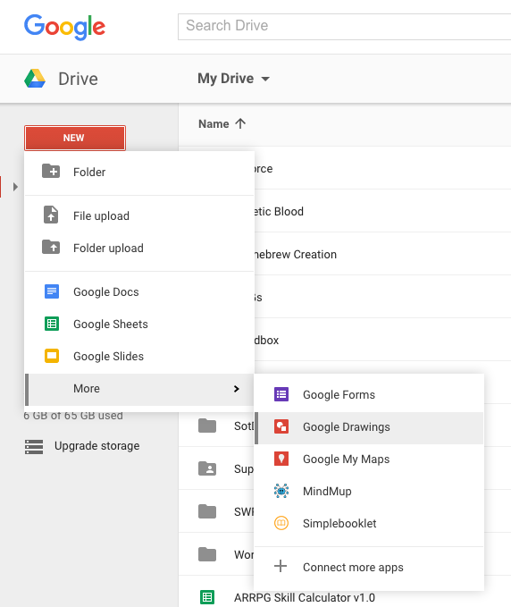
Since you're already using Google Docs to keep your campaign info I'd suggest you stick with the Google ecosystem. One of the hidden gems in Google Drive is Google Drawings. Just like other GDocs, you can set permissions for others to edit them, and it's all updated in real-time (like other GDocs).

While you can't access it via doc.google.com, if you go to drive.google.com, you can:

Google Drawings

Google Drawings has all the tools for a representative map (since you're playing DFRPG, I'm assuming you don't need a super-detailed map1 for your city). You can add shapes, lines, text boxes2, import images, and free-draw in real-time with your friends.

Your Requirements

  1. Draw a map of key landmarks and their relationship to each other. Each side needs to be able to point at/draw on it so that everyone else can see them add/remove features.

GDocs is all about the collaboration, as you know from working with their text editor. GDrawings' line, shape, and text box options cover what you are asking for.

  1. Label and write details about each landmark.

As mentioned above, you can add shapes for landmarks—or import an existing image you have to represent the landmark. Using text boxes, you can add basic descriptions to them, and reference them in your master G(text)Doc for more details.

  1. Designate and describe characters as the "face" of various locations.

With the shapes and arrows (found in the lines option) you can show relationships between places, faces, and PCs\$^3\$.

My Experience

When I did this a few years ago, we all were on a Google Hangout for communication, and used it as a "writer's room". Just like if we were at the same physical table, we threw ideas back and forth, and when something stuck with the group, I added it to the map.

Of course, I was the designated map-adder because I was the GM and the most familiar with the software. Since you have a tablet at each end of the conversation, you can easily use those to pass around if people want to add their own things to the map, or just have one designated mapper in each location. Either way, this would free up the biggest monitor/TV screen for the video chat, and give the idea of "passing around the map" if y'all were in the same location.


\$^1\$If you do want a super-detailed map, you can always use Photoshop, GIMP, Inkscape, etc and import the map as your background in GDrawings. Then anything added will be superimposed on top of the map

\$^2\$Note that you can double-click on a shape to add text directly to the shape, you do not need to add a separate text box

\$^3\$I'm a fan of the Smallville RPG system of using squares to represent PCs, circles to represent NPCs, and diamonds to represent locations

\$\endgroup\$
1
  • \$\begingroup\$ I don't think this rises to a separate answer (I may have one in a few days) but I will point out that Google Slides (and Drawings?) is also available on tablets, and can be put on a Chromecast for easier collaborative viewing. The tablet versions, which allow stylus work if you have them, are pretty awful, IMO... but you can use the Virtual Tablet (and Server) software to link tablet to PC for a somewhat better interface for freehand drawing. \$\endgroup\$
    – Novak
    Commented Jun 5, 2016 at 4:49
3
\$\begingroup\$

Given our setup, I can't easily show "the other side" the map in real-time, and they can't add to it themselves. How have you solved this problem in your games?

I didn't, because I never had that problem when I used tele-presence for DFRPG. Maps are not crucial to the Fate experience nor even the specific Dresden iteration where locations are written out. That's because things like distance is handle extremely abstractly, via zones, which can be as large or as small as you need them to be for the scene. You can create locations without any sense of geography for the city, because when you use them the only way they interact is travel between them, which Fate is designed to handle as abstraction.

When you are in the location, Sweet Ass Landmark it doesn't matter if Bad Guy's Manor is 20 miles Northwest or 5 due south. The general direction doesn't even matter, until its important for the story. Think of everything along the Heisenberg Principle. Until it's observed it could be anywhere(or anything). This is exceptional for Fate and Dresden in particular because when it does become important you can handle it via aspects. Perhaps you compel someone's Just My Luck Trouble to make is so right when the need to get somewhere, turns out it's across town and there is no clear route to get there. Or alternatively, once the group figures out the need to go somewhere an enterprising players wants to make a declaration that it's close by and they know a super fast route. Sweet, you've got them engaged.

In Dresden the players help create the world, not just at the beginning but the whole time through. The more details you nail down at the beginning the less play space you leave them for cool things to come up with later. In addition those details may never get used or become important. That's wasted effort and narrative focus. Much like in a written story, in Fate you really only want to put wants going to come up, what's important to the story in your exposition. It's that narrative focused. Give people enough to know what's going on and what they have to work with and let the rest come out during emergent play.

One of the main reasons I stress this is I've often lost groups during world creation and that was a much worse problem when done online. World building can tend tedious for alot of players after awhile. Adding the necessity of mapping everything out in relation to each other will add to the time and the to task list of things they are doing that aren't "playing the game". Obviously if your entire group enjoys mapping things that's less of an issue but I've never seen that to be the case.

When pitching locations to the group we rarely ever bothered with geolocation, except to put maybe the down the most general of notes like, this location is in a ghetto or it's near the lake. My players never ran into issues with not knowing where stuff was. They simply asked when they needed to know and between us we could come up with the thing that fit best, whether through GM fiat or through use of the mechanics.

So in conclusion if the map looks like it will add any bit of frustration to the process, don't use it, because it doesn't add much and what it does add actually removes from potential enjoyable gameplay later.

\$\endgroup\$
2
\$\begingroup\$

While this doesn't solve all of your potential problems, this is how my gaming group solved the problem of collaborative city creation in DFRPG.

The first thing to mention is that we used a real city, so that immediately eliminated the issue of having to draw up or see a street plan.

[Edited to add] We were all in the same location for the DF creation, but I don't think this gave any particular advantage that wouldn't be possible with Skype chat - I've used Roll20 and hangouts for city creation in other games in the past and it's not a very different effect.

The Faces Are The First Thing

We used the Faces as our central point, and started from the perspective of the enemies. Obviously the Dresden universe has a certain number of factions, so we listed these; Red Court, White Court, Fomor, Black Court, Venatori...you get the idea. We then decided if we wanted that particular faction in play (for example, we didn't use the Fomor or Paranet) and also to what extent we wanted them in our game (so we ended up with multiple mafia groups, but only one Red Court hangout as we wanted to avoid echoing the actual Dresden Files).

We filled out bits of the Faces sheet at this stage, but didn't try to fill them in completely. You could use a Google doc or writeable pdf for this, or share the notes that are made. If you have an online chat, you could also share images at this point if you've got someone in particular in mind for a Face.

Match the Faces to Locations

We then matched the Faces to locations. White Court...is there a local (probably infamous) strip club? The Summer Court will be somewhere lush and nature-laden; the Black Court probably want a graveyard; and we dumped our wolfpack in Technology Central as we decided they were hackers! Using the map also helped with adding other interesting bits; we had some additional ghosts, a couple of NeverNever entrances, old tunnels and caves, a dragon hideout. It also suggested some of the relations - there were points where Winter and Summer locations were very close, so hey, nice bit of squabble there. The multiple mafia ended up working quite well for a set of particular shops that are in conflict in the real world, but the Red and White Court locations were a little way apart - so a lack of conflict there. It let everyone contribute ideas, and it all helped develop the relations/politics part of the game world.

For this, we all used a generic map; I think we had a cycle map, Google maps and a Wordpress map (see below) open at the same time depending on what the individuals found easiest to work from! Because they're all generic and of the same city, it meant that everyone could see the same thing without needing to share. We then simply talked it over. There was one designated note-taker using a combination of Google Maps and scribbled notes to make a note of everything that was spoken about. This could potentially be a Google map just for the locations and a Google doc that was shared with everyone, but I'd suggest only having one "scribe" as it can get ridiculously muddled to have everyone adding notes (trust me on this one!)

However - I can appreciate that this is the part where screen or map-sharing softeware would be useful. We all knew the city well enough that we could just say "oh, that road!" and "hah, yeah, that area's a bit nasty" but if you had people that potentially didn't know your city, or weren't following closely, then it could get complex. I'd be interested to know what screen-sharing or map-sharing software people have come up with for the creation stage.

Filling In Details

Once we'd got some of the locations, we then finished filling in the Faces - some of the details did change over the course of the session as we came up with ideas, so this was the point we sorted out what we liked and what we wanted to keep. We added names, jotted down the main locations, added some notes about the potential politics (in relation to other Faces and in relation to the PCs), finalised the details of anything extra (eg. NeverNever entrances, Accorded Neutral Territory) and made sure everyone was happy with the basics.

Sharing The City

We use a wordpress website for character sheets, write-ups of sessions, and a map of the city. I used a free plugin (called MapsMarker, but there are several available) that allows for different colour and style pins on a map area of your choice, and also allows notes on those pins that show when you click on them as well as below the map. There's options for different views and layers, and I found it fairly easy to use. I completed this after the city creation session was done, in time for the first gaming session.

The website was our central 'hub' for information, and having the map with additional locations helped with games; the GM sometimes added extra things before a particular session (eg. a murder location) so that we could see what was there. We did use a projector for a while but ended up not needing it - the real-world city knowledge mostly meant once we knew one location, we could remember where everything else was in relation to it. But if you were playing at a distance as well, it would make a good wiki-style base for everything.

The Ongoing Game

It's worth remembering that you'll likely need to change your city as the game plays out. Having the customisable map on the Wordpress site meant we could add and remove (destroying bits of the city? Us? ahem) locations as we needed, and also add more factions - for example, if the Fomor did pop up, or we wanted a location added for a one-shot. We also kept track of the politics on the website, as the relations between the Faces changed as much as the relations of the Faces to the PCs. The customisable map also meant we could bounce off to other locations if we needed to, which gave the GM a bit more scope for "chasing the baddies" or similar fun.

TL;DR

We used generic maps of the city, a shared Faces files or a shared document for the notes, and then talked in a group about the locations we wanted to use for each faction. This was then written up later onto a customisable Wordpress map that was then used in-game and added to for the rest of the campaign.

\$\endgroup\$
2
  • \$\begingroup\$ It's very hard to tell from the way this answer is written, but it sounds like you used digital tools, but were physically all in the same location. Is that the case? If that's wrong, this answer could use more description of the actual situation, and what issues it caused and how they were solved. \$\endgroup\$ Commented Jun 3, 2016 at 16:02
  • \$\begingroup\$ That is correct, we were in the same location but I think the same effect would be possible with the Skype chats. I'll rephrase! \$\endgroup\$
    – Houdini
    Commented Jun 3, 2016 at 19:18
-2
\$\begingroup\$

First of all, I want to inform that City Creation system in Dresden Files is not something unique. Similar methods are used by more experienced developers for nearly everything. It is not my own words, but from many other developers and even publishing companies. I used nearly identical rules while creating or helping with setting and their worlds, with unique cities, wilds, characters, etc. Dresden Files is not unique.

Tools

To create a good City, you will need to use 2 or 3 programms:

  • some sort of sketchboard
  • a text editor
  • depending if an actual handout map is wanted, a graphic editor

All the people taking a part in this creation should familarize with the first two of them.

Roll20 is good for playing, however if you'd like to create something in it and keep for further use, it is bad. It is not a good tool for development.

For mentioned before "digital sketchboard", I'd highly recommend you Deekit. It needs you to sign up, however you can simply do it with Facebook, Github, Google, Microsoft, Linkedin, Twitter or Trello account.

It has everything that could possibly needed:

  • inviting via an e-mail and colaborating
  • drawing tools: pen, brush, marker
  • drawing shapes: line, rectangle, elipse, polygon, vector
  • Copy pasting
  • Uploading your own images
  • Notes
  • Exporting the outcome into a png file

Everything is pretty clear and it is unlikely for someone to get lost in it's features.

This tool will be helpful to write down overall ideas and sketches for points 1-9 of City Creation in Dresden Files.

For details I'd recommend to stay with google docs, as you mentioned.

This could be used for detailed descriptions associated with points 8-14.

Group project

First of all, the proper communication between the groups is a must. Make sure that your connection is stable, programms are update and there is practically no possibility for technical issues.

Generally speaking, the best possible solution would be if everybody had their own computer(not a tablet, as they are pretty limited).

If you think that a few people would work over one machine, then another solution will be better. Something that is used on a real life brainstorm, like one person is writing on a whiteboard and the rest provides bright ideas. Similarly, in each group there will be one person responsible for writing and sketching in Deekit. The rest will just stick to providing ideas and consensuses. Then, on both sides, the chosen writers/sketchers will share responsibilities. Each one of them will develop chosen subjects, like mortal response to the supernatural, selected NPCs, themes, threats, locations and connections between them.

Experience

To be honest, I helped a lot in a homebrewing/freepublishing internet community. We've been mainly creating settings, small boardgames or small systems via web. Mostly creating content that was free, we primarily used freeware. To communicate we used Skype or Google Handouts. The overall results of brainstorms were sketches and notes created with Deekit. (everybody wrote a few key words about their ideas, connections between them that were previously mentioned).

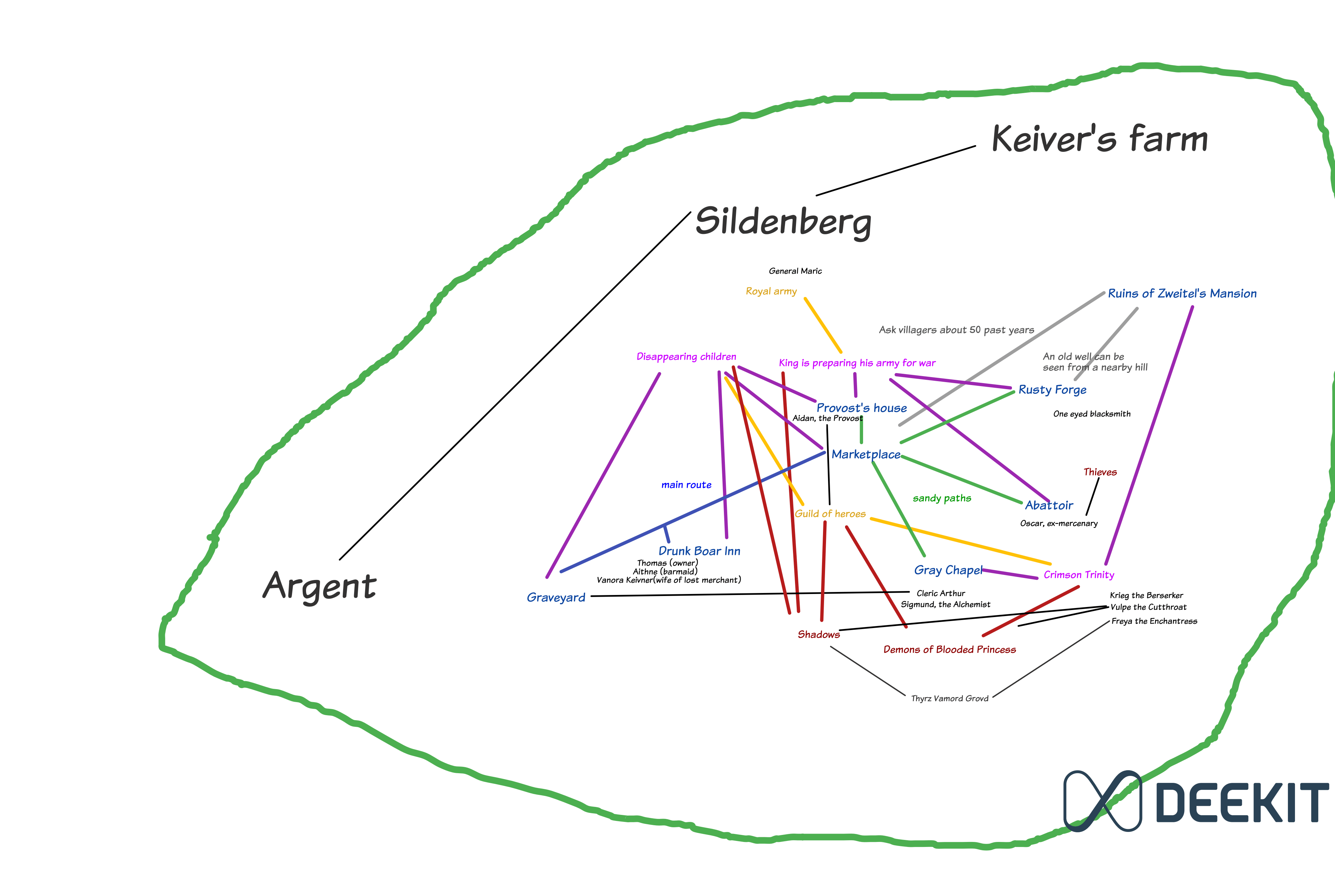
There is an example of Deekit:

An overall sketch of Village Silderberg for Dungeon World Game More distant locations are written with big black letters. Fronts are written in red. Crucial events are written in violet. Locations are written in blue. Important NPCs are written in black.

\$\endgroup\$
5
  • 5
    \$\begingroup\$ This seems to be quite a generic answer, and doesn't address the specific needs given for the Dresden creation process. Would it be possible for you to address these specifically please? \$\endgroup\$
    – Wibbs
    Commented Jun 2, 2016 at 11:26
  • \$\begingroup\$ There is nothing specific in the Dresden. It is just like creating anything. Trust me, as a homebrew society member, I know what I am talking about. A setting/system/worldmap etc. there aren't so many differences between them. \$\endgroup\$ Commented Jun 2, 2016 at 11:34
  • 4
    \$\begingroup\$ The "Back it up" principle suggests that this question would be better received if it contained some variation on the formula "I have used tool X for task Y, which seems similar enough to your task Z in ways A, B, C, that tool X will probably work for task Z too." (I have no idea what being a homebrew society member entails, and I would not automatically assume it means online collaborative worldbuilding.) \$\endgroup\$
    – BESW
    Commented Jun 2, 2016 at 11:42
  • \$\begingroup\$ I am happy to be told (I assume this is what you mean?) that Roll20 has no save-and-export feature, though! That's very useful to know. \$\endgroup\$
    – BESW
    Commented Jun 2, 2016 at 11:47
  • 2
    \$\begingroup\$ How well has this worked when it's not multiple people with their own computers, but two groups? Does it work for each group to gather around one computer, or is crowding a problem? Must each participant have their own computer for this to flow well? Are there any problems in ease of collaborating caused by having two groups (who can communicate with their own members more easily) coordinating through Deekit—does the computer become a bottleneck, or is group collaboration just as good as when the two groups are face to face? \$\endgroup\$ Commented Jun 2, 2016 at 14:24

You must log in to answer this question.

Not the answer you're looking for? Browse other questions tagged .