51
\$\begingroup\$

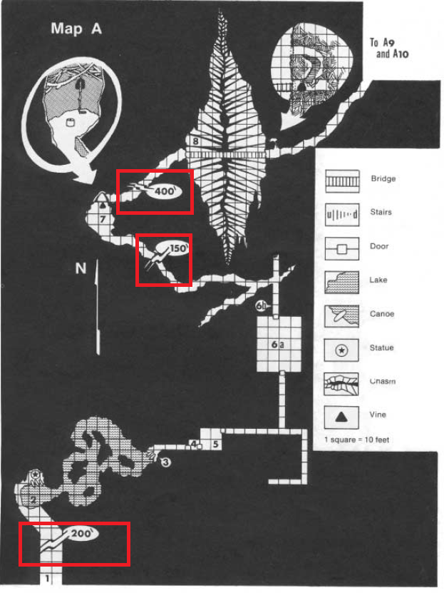
Looking at the map for area A and area C of I1 Dwellers of the Forbidden City, there are several markings that are not on the legend for the map. In each case, a corridor is interrupted by a zigzag connected to a small oval with a number and a tick mark, like an apostrophe. At first, I thought they were chasms with the depth indicated, but this doesn't seem to be referenced anywhere in the module.

Can anyone identify these markings?

Can anyone identify these markings?

\$\endgroup\$
0

3 Answers 3

105
\$\begingroup\$

Those are "breaks" indicating that the cave keeps on going generally in the same way for X feet (' being the abbreviation for "feet"). Drawing that all out would make for scale problems on the interesting parts of the map, so long runs of identical cave are elided and those notations added.

Real world e.g. cave maps have similar devices, though not always looking exactly like this.

\$\endgroup\$
3
  • 3
    \$\begingroup\$ I think you are right - but the cartographer has got the symbol for feet wrong. They have used ` rather than ´. \$\endgroup\$ Commented May 17, 2017 at 15:04
  • 1
    \$\begingroup\$ This would be even better if you had a source for the real-world map claim \$\endgroup\$ Commented May 17, 2017 at 20:44
  • \$\begingroup\$ I haven't seen it for maps before, but it's a common solution for graphing datasets with outliers (it's normally called a 'broken axis'), although it's not best practice. See: google.co.uk/#q=broken+axis \$\endgroup\$
    – tardigrade
    Commented May 18, 2017 at 12:20
32
\$\begingroup\$

That means the passageway is actually longer than the map shows. The distance mark indicates how much longer.

Note that the passageways on both sides of the mark have the same basic style and direction. That implies the omitted section has that same style and direction. In essence, "more of this"...

Sometimes you have to watch out. For instance the prominent chasm is actually northeast of room 6.

\$\endgroup\$
1
  • 9
    \$\begingroup\$ +1 for pointing out how the map can be misleading due to the varying distances (NE of room 6), which isn't in the other answer. \$\endgroup\$
    – DCShannon
    Commented May 15, 2017 at 23:21
6
\$\begingroup\$

You will note that each square on the map is equal to 10 feet. That means that the top portion would be 40 squares (10 inches with typical 1/4" squares) of rather uninteresting passageway. The author uses this as a break to indicate that stuff continues as before and after the break. This link shows how they work in a graph in Excel.

\$\endgroup\$
0

You must log in to answer this question.

Not the answer you're looking for? Browse other questions tagged .