Do the maps of cities in the 3rd Edition Forgotten Realms Campaign Books accurately reflect the statistics of those cities?
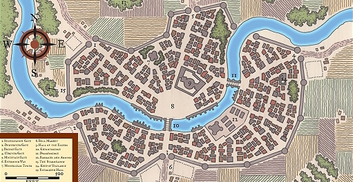
I recently decided to use the city of Everlund from the Forgotten Realms campaign setting as a model for a location in a one-shot scenario - the setting was not exactly the same as Faerun, but it was a similar generic setting of my own creation with a similar version of the city as the focus of the story. Upon comparing both the map and the statistics provided in the book (the information of which is also available online), however, I found that the numbers did not seem to line up to me:

Population: 21,388
The population seems far too large, and the physical city and number of possible residences far too small, for them to match relative to each other. I have not counted the exact number of buildings, but estimate a couple hundred - a number that would suggest around 100 people per house. Even with the expectation that people live in larger families and with a higher density-per-house than our modern real-world, this seems like an absurd number. I might expect it to be something more like an order of magnitude smaller. Making sure that this was not just an isolated case, I found that most other cities with drawn maps seemed to have a similar situation.
I've considered that the creators might have intended these maps to not be taken literally, but rather abstractly - each square not representing a literal single building, but rather the general shape of areas being taken as general districts. This does not really seem to make sense, though, when you consider what they have detailed - individual bridges, roads, larger key buildings, and an important river, all drawn to scale and with an appropriate measuring ruler in the bottom corner. If this is meant to be taken abstractly, it is certainly hard to wrap my head around.
Are the maps simply too small for their statistics? Are they actually reasonable, contrary to my beliefs? Are they meant to be literally accurate or interpreted more broadly?

